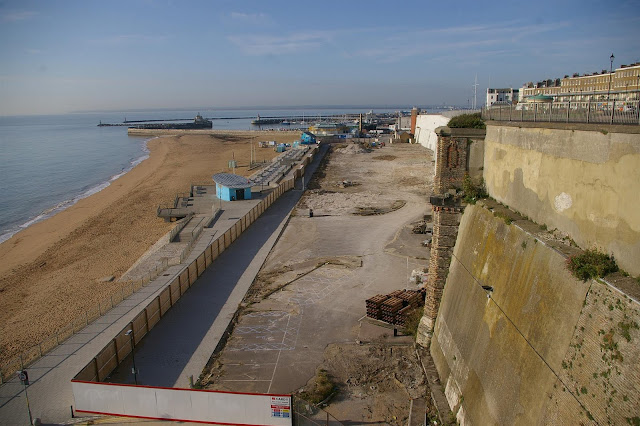
Ramsgate Main Sands is the beach on the east side of
Ramsgate Harbour and what I am talking about here is the is the part of the
sands not covered by the sea at high tide.
When you first look at the beach it is easy to assume that
it has been formed by sand collecting because of the shelter of Ramsgate
harbour.
The red line on the picture shows the approximate high tide
line from around 1940 to around 2010 and the blue line the approximate high
tide line now.
One way or another we have lost a lot of sand.
Back in the early 1700s before Ramsgate Harbour
was built, Ramsgate had a pier a bit like the one in Broadstairs and a small
beach collected there, high tide mark in red.
Ramsgate Harbour was built during the last half of the 1700s and this picture shows the beach then.
During Victorian times it looks like a bit more sand collected above the high tide line around where the pavillion is now, this is an oil sketch done by William Powell Frith in 1850 for his famous painting of Ramsgate Sands.
Here is the famous painting, don't take much notice of the colour differences, which are more down to the way the originals were photographed than anything else.
The Pavilion was built in 1904 and all of the pre war pictures show the high tides covered all of the sand.
Between the wars the sand above the high tide mark started to build up, I was told by Don Long that this was due to the the sand being held in place by the war time beach defences, concrete block and barbed wire.
More of this in WW2 and as I say this situation was maintained up to the 1960s.
In the 1970s a lot of the sand from Ramsgate Main Sands was removed and used for the infill in the building of Port Ramsgate, my understanding is that a lot of the buried wartime beach defences that held the sand in place went with it.
In the 1990s Ramsgate dredger that steadily dredged Ramsgate harbour and dumped the sand from the dredging where it would be swept onto Ramsgate Sands was sold.
Not much happened for some time this is another 2010 picture.
In 2013 the sea seemed to be cutting away the front of the sands.
This was the 2014 situation.
and this about a month ago. The most worrying aspect of this is the sea defences behind the main sands haven't been in contact with the sea for around 100 years and now with the sand going they may not hold.


During Winter with North East gales the heavy seas would always move sand to the west, but on a change of wind with the south west and Southerly gales it would be moved back, since the ferry terminal has been in place there is no wave action to shift it back the natural balance has been destroyed. Older residents will remember the shingle banks that were in place one at the boundary of King George Park called Moses bank the other in the middle of the main sands, both of these banks have now shifted west one straddles the groin a shift of several hundred metres the other is almost up to the the East pier. Our beach is on a one way trip to fill the lovely Royal harbour up where from time to time it gets dredged up and dumped on the spoil ground, never to return, so we are paying to lose our own beach. The solution would be to redesign the breakwaters by taking the one that comes from the East pier head and building it to curve from where the outer end is and run towards the middle of the main sands, this would stop the heavy NE swells from rebounding off the East pier and taking sand towards the entrance. {Ron Blay former dredger master}.
ReplyDelete