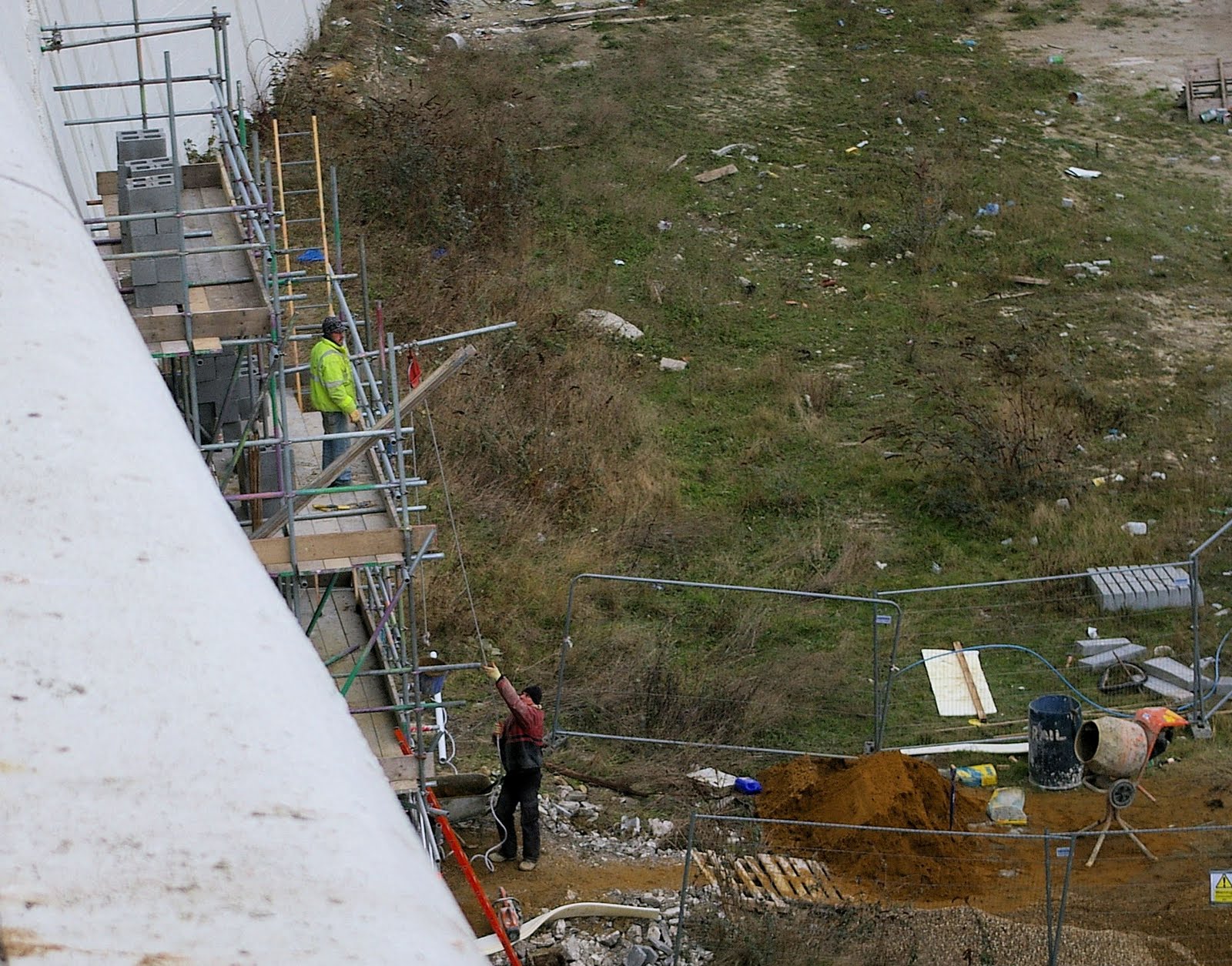
 Work is in progress removing the loose bits of the cliff wall.

News, Local history and Thanet issues from Michael's Bookshop in Ramsgate see www.michaelsbookshop.com I publish over 200 books about the history of this area click here to look at them.
Friday, 8 October 2010


Thursday, 7 October 2010
Is Thanet District Council prepared to put out lives at risk?
 Of all of the strange situations that I have found myself in dealing with the council, this one I think takes the biscuit, and I have now made an official complaint about it.
On Monday I pointed out to them that there was a bit of lose masonry hanging about forty feet over people’s heads, well it’s Thursday and when I looked earlier today it was still there.
No warning sign no barriers, just hanging over a place where anyone can walk, anyone’s children play, it is just plain potty.
Hi this is a complaint relating to public safety and as such could you please deal with it expediently, please quote this reference in any reply Pleasurama complaint 71010.
The following is background to impress on you the urgency of this situation.
On 27th September 2010 I emailed the council’s engineer, chief of development services, chief executive, the officer dealing with the development and the leader of the council expressing concerns about the safety of the Pleasurama cliff.
On the same day I telephoned the HSE about the same issue, particularly with reference to the construction workers now working beneath the cliff.
On the 29th September 2010 the HSE telephoned me and told me, that they had contacted the council and that the chief of development services had assured them that there were no safety issues relating to the cliff.
During last weekend part of the cliff large enough to kill or seriously injure someone below, I would estimate that this cliff wall masonry weighed about 50 kilos fell from a height of about 15 metres, partly into the construction site and partly onto the public highway.
This has left further loose masonry hanging above where the building site joins the public highway.
On the following Monday 4th October 2010 I discussed this with the council’s engineer and was assured that some sort of action would be taken to make the site and public highway safe.
Not the proper and thorough examination of the cliff that I requested, but measures to remove the lose bits and or cordon off the area below them.
I have just visited the site and while the loose masonry is still hanging there no measures have been taken to protect the public.
I wish to complain that the council has taken no action in this instance to protect public safety and has failed in its duty of care.
Wednesday, 6 October 2010
How high is high tide at Ramsgate?
 With the various developments proposed and ongoing on the foreshore in Ramsgate, most particularly the proposed one on the harbour slipways, I have been looking at the various tidal flood risk assessments.
I spent some time today discussing the flood risk assessment for the slipways development with the chap who wrote it and as far as I can see there have been various errors made and problems relating to access of full and accurate information both about the development and the local tide statistics, by the person writing the flood risk assessment.
One thing that is petty simple here is that the development is to be built on three levels, undercroft, ground and first floor. Unfortunately it seems that the planning sheet showing the undercroft wasn’t passed on to the firm preparing the flood risk assessment.
Engineering hat now, so I would suggest just taking my word that people in the bar the ground floor may get wet feet, unless you have some patience.
OK for those who are following into the higher country of the mind here, I want you to think about just exactly how high, high is. Start with something big that is easy to think about, Mount Everest is at 29,002 feet or 8,840 metres high, you can check this if you want, but the question you may not have asked is higher than what?
OK if you said sea level, you are doing pretty well here, but the sea goes up and down so what sea level?
If you live in Ramsgate then you have probably have seen the levels marked next to the lock gate, between the inner and outer harbour so you may think that it is level that I am talking about.
It indicates that the harbour wall is about 6 metres above sea level. So you would assume that the top of Mount Everest is 8,834 metres above the harbour wall in Ramsgate.
I am afraid to say that you may be wrong the levels written on the harbour are in chart datum, but when in 1856, the Great Trigonometric Survey of British India established the height of Everest the surveyors used ordnance datum.
Ordinance datum is 2.58 metres (about eight foot six inches) higher than chart datum.
Architects use ordnance datum on their planning sheets and information about tides and sea levels is measured in chart datum, make a mistake about this and you may be in deep water.
This wasn’t the mistake that happened with any of the plans for developments on Ramsgate’s foreshore, but I think the confusion around it helped to cover some up.
Now to save confusion here I am going to take off my engineers hat and put on my sailors hat, so it’s time to say, “hello sailor.” If you didn’t think I could do this see http://thanetonline.blogspot.com/2007/12/friggin-in-rigging.html or http://www.michaelsbookshop.com/cryfromthesea/index.htm
All of the figures below are in chart datum.
The lowest indoor bit of the proposed development on the slipways is 6.18 metres above chart datum.
I think some of the confusion has come from, the figure 5.4m is the MHWS for Ramsgate, the flood risk assessment takes this to be about the highest astronomical tide, this actually stands for mean high water spring, i.e. the average height of a spring tide and not the highest astronomical height.
HAT - Highest astronomical tide is the one they should have used the HAT at Dover is 7.3m the difference for Ramsgate is 1.6 giving a HAT for Ramsgate of 5.7
The highest recent tidal surge locally was 14th Feb. 1989 at 10:00 hours this was 1.84 metres above normal high tide registered on the Dover tide gauge, as tidal surges are caused by low barometric pressure the level would be about the same for Ramsgate.
I would think it reasonable to assume that adding the HAT at Ramsgate to the surge would give the best idea of the highest possible spring and surge level here i.e. 7.54 metres.
We would be very unlucky to have a tide this high now, the tidal surge of 1953 was 8.22 m at Dover which works out at 6.62 for Ramsgate, this surge was combined with a severe storm, though fortunately not a spring tide.
In the 1953 tida1 surge 1,835 people were killed in the Netherlands and 307 were killed in the United Kingdom and about 250 people were killed at sea, many of them sailors.
A problem with the sea is that it has waves, I suppose the fact that it killed over 2.500 people in this part of the world during one storm, is a testament to this.
This means that anyone contemplating building on our foreshore needs to consider how high the waves here can get.
Several factors determine how high the waves will get in a storm, once again there are different ways of expressing the height of a wave, as I have my sailors hat on I will use the one called significant height, this is the height difference between the trough between the waves and the crest on the waves.
One factor is the strength (speed) of the wind, as a sailor I will express this in knots, nautical miles per hour, a nautical mile is a little bit longer than a statute mile.
In the days of sail sailors measured the speed of their ship with a line with equally spaced knots tied in it and a lump of wood on the end. One of them dropped the bit of wood over the side and counted how many knots passed through his hands, while another one timed this with a glass, something like a big egg timer with sand running through it.
Another factor is the duration of the storm, the longer the wind blows for the higher the waves, this has a saturation time after which the waves don’t get any bigger.
Another factor is the fetch of the sea, this is how far it is between the shores along the line of the wind direction.
 There are other factors but I think we will stick to those, otherwise it is going to get scientific and didn’t wear a hat when I worked as a scientist.
As Michael Fish said there won’t be a hurricane so we certainly don’t need to worry about 11 metre waves on a worse case scenario 7.45 metre tide.
You will be glad to know that the depth of water mitigates the height of the waves.
The worst we have had in recent years was in 1953, because of the wind direction we were sheltered in Ramsgate, the waves were also mitigated here because the fetch was across the Straights so Dover and not along the Channel.
I would say about 7 metre waves on a 6.62 metre tide.
The environment agency say that new developments should be assumed to have a life of 100 years, the best predictions for the rise in sea level by 2110 are between 1 and 2 metres, they are working on just over a metre.
They are saying that by then we should be expecting static tides of about 8 metres above sea level here in Ramsgate and building now to accommodate for them.
Obviously there have to be compromises here a balance between the worst case scenario, which is a 2 metre sea level rise and 7.45 metre tide with 11 metre waves and what is likely to happen in reality.
Normally anyone producing a flood risk assessment will have considered the sea defences in front of the development and how far behind them the waves will be broken up enough to stop them damaging the building.
This isn’t an option with the slipways development as it is to be built on a small pier, so the waves will be under it as well as in front of it.
With the Pleasurama development there hasn’t even been a flood risk assessment, so no one has even bothered to consider the problem.
Tuesday, 5 October 2010
Ramsgate Seafront Developments a bit of ramble
Having just phoned the architects for the slipway because their flood risk assessment just doesn’t make any sense, this is really case of time is running out to comment on the application and the flood risk assessment appears to have errors in it.
What is seems to be saying is something akin to the tallest person is four feet high, therefore we propose to build as house with all of the ceilings five feet high.
There are several examples of this in the document, here is one of them; it actually says on page eleven of the document is. “Spring tides can reach 5.4m above chart datum”.
This weeks tides see http://easytide.ukho.gov.uk/EasyTide/EasyTide/ShowPrediction.aspx?PortID=0102&PredictionLength=7 Thursday 5.4m, Friday 5.6, Saturday 5.7.
Now you would think that the architects would have something to say about this, some sort of explanation, but know it would seem that my only approach here is to use this as part of my grounds for objecting to the development.
Next door to this site is the pavilion and here they seem to be painting and filling the cracks in the outside, with no real reference to the problems inside the building.
Also this work seems to be going on without any thought to the flood protection, it would seem that a lot of money is to be spent on Margate’s flood protection, but nothing on Ramsgate’s.
I wonder if the council have read the wrong figures for a high tide in Ramsgate too, this is something that would explain quite a bit.
Over the road the building on the back of the Belgian Café is still proceeding with the windows about a metre lower that they should be according to the plans.
Back to my conversation with the architects for the slipway development, they really don’t seem to appreciate that what they are building is in fact a short pier and that the building of piers is a specialist business.
I asked about wave heights and the architect that I spoke to said that this wasn’t a problem with the Clock House, he didn’t seem to understand that the stone apron at the back of the Clock House dissipates the waves, something that doesn’t happen with a pier.
On to the Pleasurama site, all work seems to have stopped there now, understandable really now I know the sequence of events, which is.
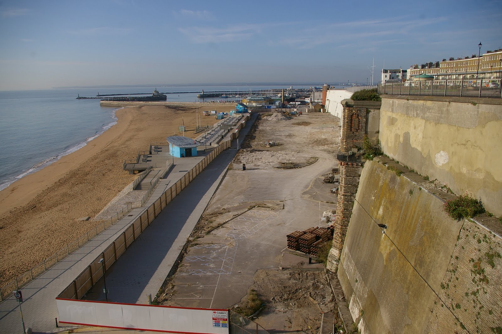
Cardy Construction the people building the development started clearing the site about a month ago, this has exposed the bottom of the cliff wall, which frankly looks a bit dodgy.
I now know from the HSE that they expressed concerns about the cliff wall, foundations, weeds, cracks, strange damp patches and so on to the council.
The council reassured them saying that the cliff wall was perfectly safe and work continued.
Then a lump of it fell off that was big enough to kill someone below.
Now they have stopped work and left the site.
The HSE have now told me that they are going to send one of their construction engineers to visit the site.
During the war cliff maintenance, weed removal, keeping the drains clear and so on didn’t happen as people were busy fighting Hitler and after the war we had several cliff collapses in Ramsgate.
Once again and I don’t really know why cliff maintenance seems not be happening quite as it should, this is an example from another part of Ramsgate.
 The picture above is of another blocked drain and illustrates what I mean about recent cliff maintenance about as clearly as I can.
The pictures below are of when this part of cliff in Ramsgate collapsed just agter the war.


 The pictures apart from the one I took at the top, are courtesy of Margate Museum, click on them to enlarge them and click on them again to make them even bigger.
What is seems to be saying is something akin to the tallest person is four feet high, therefore we propose to build as house with all of the ceilings five feet high.
There are several examples of this in the document, here is one of them; it actually says on page eleven of the document is. “Spring tides can reach 5.4m above chart datum”.
This weeks tides see http://easytide.ukho.gov.uk/EasyTide/EasyTide/ShowPrediction.aspx?PortID=0102&PredictionLength=7 Thursday 5.4m, Friday 5.6, Saturday 5.7.
Now you would think that the architects would have something to say about this, some sort of explanation, but know it would seem that my only approach here is to use this as part of my grounds for objecting to the development.
Next door to this site is the pavilion and here they seem to be painting and filling the cracks in the outside, with no real reference to the problems inside the building.
Also this work seems to be going on without any thought to the flood protection, it would seem that a lot of money is to be spent on Margate’s flood protection, but nothing on Ramsgate’s.
I wonder if the council have read the wrong figures for a high tide in Ramsgate too, this is something that would explain quite a bit.
Over the road the building on the back of the Belgian Café is still proceeding with the windows about a metre lower that they should be according to the plans.
Back to my conversation with the architects for the slipway development, they really don’t seem to appreciate that what they are building is in fact a short pier and that the building of piers is a specialist business.
I asked about wave heights and the architect that I spoke to said that this wasn’t a problem with the Clock House, he didn’t seem to understand that the stone apron at the back of the Clock House dissipates the waves, something that doesn’t happen with a pier.
On to the Pleasurama site, all work seems to have stopped there now, understandable really now I know the sequence of events, which is.
Cardy Construction the people building the development started clearing the site about a month ago, this has exposed the bottom of the cliff wall, which frankly looks a bit dodgy.
I now know from the HSE that they expressed concerns about the cliff wall, foundations, weeds, cracks, strange damp patches and so on to the council.
The council reassured them saying that the cliff wall was perfectly safe and work continued.
Then a lump of it fell off that was big enough to kill someone below.
Now they have stopped work and left the site.
The HSE have now told me that they are going to send one of their construction engineers to visit the site.
During the war cliff maintenance, weed removal, keeping the drains clear and so on didn’t happen as people were busy fighting Hitler and after the war we had several cliff collapses in Ramsgate.
Once again and I don’t really know why cliff maintenance seems not be happening quite as it should, this is an example from another part of Ramsgate.
 The picture above is of another blocked drain and illustrates what I mean about recent cliff maintenance about as clearly as I can.
The pictures below are of when this part of cliff in Ramsgate collapsed just agter the war.


 The pictures apart from the one I took at the top, are courtesy of Margate Museum, click on them to enlarge them and click on them again to make them even bigger.
I should stress that this was only one of several cliff collapses in Ramsgate and that the most likely cause of them was poor maintenance.
The trouble is that once water has damaged the chalk cliff it stays damaged. It doesn’t really matter what is done to the cliff facades, it is the condition of the thousands of tons of chalk behind them that causes the problems.
The trouble is that once water has damaged the chalk cliff it stays damaged. It doesn’t really matter what is done to the cliff facades, it is the condition of the thousands of tons of chalk behind them that causes the problems.
In a natural state it is the sea undermines the chalk and the cliff steadily collapses at about the rate of a foot a year, so if man hadn’t intervened with sea defences then most of our famous cliff top buildings in Ramsgate would have already fallen into the sea.
I don’t fully understand the business of building foreshore and under cliff developments here in Thanet recently.
We had a spate of this mostly in Victorian times when either these were leisure buildings, most of which have now vanished, like Ramsgate and Margate piers or most of the other Thanet pavilions. Or they were major pieces of civil engineering integrated with the cliffs, like Westcliff Hall, The Winter Gardens or the arches in Ramsgate.
We had a spate of this mostly in Victorian times when either these were leisure buildings, most of which have now vanished, like Ramsgate and Margate piers or most of the other Thanet pavilions. Or they were major pieces of civil engineering integrated with the cliffs, like Westcliff Hall, The Winter Gardens or the arches in Ramsgate.
Now we seem to have a group of developers that only ever seem to have experience of building inland who seem to think that they can ignore the major civil engineering challenges posed by these sites and just build any old thing there.
Monday, 4 October 2010
Royals Sands Development, Pleasurama Cliff, a lump falls off
Over the weekend a lump of the cliff façade fell off. What is important to stress here is that last week the council assured the HSE that this façade was safe enough for people to work underneath and safe enough to build a residential development next to it.
During the weekend the part of the façade that will be above the main entrance to the new development shed enough masonry to kill a person standing below.
 The missing bit that that it where it fell from is in the picture above, you can also see the bit next to it is lose.
 You can see from the picture above (a detail from one of the pictures in Saturdays post) that it was there last week.
First I phoned the Health and Safety Executive and spoke to the chap I spoke to last week, I wasn’t really sure what action they intend to take, he said he would talk to his supervisor.
He suggested that I phoned the council’s building control department, unfortunately the building control officers were either in meetings or out on site.
 Here is the bigger picture of now
 and here the bigger picture of last week.
 as I said before part of this structure collapsed in the 60s and so the potential hazard may be much more than it first seems.
During the weekend the part of the façade that will be above the main entrance to the new development shed enough masonry to kill a person standing below.
 The missing bit that that it where it fell from is in the picture above, you can also see the bit next to it is lose.
 You can see from the picture above (a detail from one of the pictures in Saturdays post) that it was there last week.
First I phoned the Health and Safety Executive and spoke to the chap I spoke to last week, I wasn’t really sure what action they intend to take, he said he would talk to his supervisor.
He suggested that I phoned the council’s building control department, unfortunately the building control officers were either in meetings or out on site.
 Here is the bigger picture of now
 and here the bigger picture of last week.
It was becoming obvious that I wasn’t getting very far and that my next port of call would have to be the fire brigade.
The problem here though is the blocked drain, featured in the previous post, the question being is the whole structure full of water and likely to collapse
 as I said before part of this structure collapsed in the 60s and so the potential hazard may be much more than it first seems.
See http://www.michaelsbookshop.com/blogpicts11/id14.htm
If it isn’t dangerous then it will be a bit embarrassing for me but if it is it could be fatal to the firemen or anyone else who messes about with it.
Anyway I stressed the importance of the drain to the fire officers and they went off to look at it.
Finally the council’s building control engineer phoned up, we then had a fairly heated discussion about the whole structure.
I pointed out that I had asked him a year ago to put up signs preventing heavy vehicles from driving on the footpath at the top of the cliff.
That the cliff needs a proper survey.
That a bit of cliff that bits periodically drop of isn’t suitable to have a building with over 1,000 people in it 4 metres away from it.
If it isn’t dangerous then it will be a bit embarrassing for me but if it is it could be fatal to the firemen or anyone else who messes about with it.
Anyway I stressed the importance of the drain to the fire officers and they went off to look at it.
Finally the council’s building control engineer phoned up, we then had a fairly heated discussion about the whole structure.
I pointed out that I had asked him a year ago to put up signs preventing heavy vehicles from driving on the footpath at the top of the cliff.
That the cliff needs a proper survey.
That a bit of cliff that bits periodically drop of isn’t suitable to have a building with over 1,000 people in it 4 metres away from it.
At least he has agreed to put some fencing at the bottom to stop people going where the bits are falling and to get a cherry picker and have a look at the cliff.
Saturday, 2 October 2010
Royal Sands Development Ramsgate, Pleasurama Cliff, is it Safe?
Once again this development has problems, a minor symptom here is that small bits of the cliff façade have been falling onto the site from above for some time.
 You can see the problem in the picture above, click on it to enlarge and then click on it to enlarge some more.
 This is a close up of the problem, this is not such a worrying problem – the bits falling off that is – as you may think, cliff safety to an extent is governed by the laws of chance, there really isn’t another economic way of dealing with the problem.
We overcome this problem by having signs saying don’t sit under the cliff. Lets say for example we have a bit cliff where bits fall off about four times a year, there are 525600 minutes in a year, let us also say that the danger posed from a fall lasts for 15 seconds so that in the course of a year there is a minute where you could get hurt being under this bit of cliff.
You can see that the danger of getting hurt is relative to the time you spend under the bit of cliff, walk under it occasionally and the chances of being hurt are thousands to one. Sit under the cliff every day during the summer and you start to get to something like a 1 in 4 chance of being hit by a bit of falling cliff.
Build your house under the cliff, or start on a 4 year contract to work under the cliff and you can see that a serious problem emerges.
With the Pleasurama site we have a situation where parts of the cliff wall have visible problems and parts periodically drop off, in fact a classic do not sit under the cliff situation.
The bit in the pictures above with the masonry falling off is part of the old railway tunnel entrance, bridge and steps, built in the 1840s.
 The picture above shows the fire brigade digging through the rubble looking people buried when part of this 1840s structure collapsed in 1967.
There are several factors that cause large collapses, one being building cliff walls as they hold back smaller falls until there is sufficient weight of chalk to cause the wall to fail.
Another factor is surfacing the top of the cliff, as when the surface cracks the rainwater is concentrated in one place, the crack, causing localised damage to the chalk below.
The main cause of cliff falls though is poor drainage of the surface above the cliff.
 You can just see the edge of the cast iron drain grill in the bottom right hand corner of the picture above, the drain in question is completely full of earth and I had to push some of the weeds growing in it, out of the way to expose the grill for the photograph.
 This is the same drain viewed from further away, unfortunately it is at the edge of the top of the cliff above the 1840s part of the cliff wall, in the photographs above.
The other bit of the cliff wall, that has problems that are visible, is at the other end of the Pleasurama site
 You can see from the picture above that the bit of the cliff wall in the middle at least looks like a reasonable piece of civil engineering, it is a series of arches with an infill. It all slopes towards the cliff by the same amount, hasn’t got many cracks in it or weed growing out of it.
 You can also see from the picture above that the other bit of the cliff wall, the bit I am concerned about that runs between the middle of the site and the lift is a bit of a mess.
 You can see the problem in the picture above, click on it to enlarge and then click on it to enlarge some more.
 This is a close up of the problem, this is not such a worrying problem – the bits falling off that is – as you may think, cliff safety to an extent is governed by the laws of chance, there really isn’t another economic way of dealing with the problem.
We overcome this problem by having signs saying don’t sit under the cliff. Lets say for example we have a bit cliff where bits fall off about four times a year, there are 525600 minutes in a year, let us also say that the danger posed from a fall lasts for 15 seconds so that in the course of a year there is a minute where you could get hurt being under this bit of cliff.
You can see that the danger of getting hurt is relative to the time you spend under the bit of cliff, walk under it occasionally and the chances of being hurt are thousands to one. Sit under the cliff every day during the summer and you start to get to something like a 1 in 4 chance of being hit by a bit of falling cliff.
Build your house under the cliff, or start on a 4 year contract to work under the cliff and you can see that a serious problem emerges.
With the Pleasurama site we have a situation where parts of the cliff wall have visible problems and parts periodically drop off, in fact a classic do not sit under the cliff situation.
The bit in the pictures above with the masonry falling off is part of the old railway tunnel entrance, bridge and steps, built in the 1840s.
 The picture above shows the fire brigade digging through the rubble looking people buried when part of this 1840s structure collapsed in 1967.
There are several factors that cause large collapses, one being building cliff walls as they hold back smaller falls until there is sufficient weight of chalk to cause the wall to fail.
Another factor is surfacing the top of the cliff, as when the surface cracks the rainwater is concentrated in one place, the crack, causing localised damage to the chalk below.
The main cause of cliff falls though is poor drainage of the surface above the cliff.
 You can just see the edge of the cast iron drain grill in the bottom right hand corner of the picture above, the drain in question is completely full of earth and I had to push some of the weeds growing in it, out of the way to expose the grill for the photograph.
 This is the same drain viewed from further away, unfortunately it is at the edge of the top of the cliff above the 1840s part of the cliff wall, in the photographs above.
The other bit of the cliff wall, that has problems that are visible, is at the other end of the Pleasurama site
 You can see from the picture above that the bit of the cliff wall in the middle at least looks like a reasonable piece of civil engineering, it is a series of arches with an infill. It all slopes towards the cliff by the same amount, hasn’t got many cracks in it or weed growing out of it.
 You can also see from the picture above that the other bit of the cliff wall, the bit I am concerned about that runs between the middle of the site and the lift is a bit of a mess.
It doesn’t have the look of being designed and is all different angles and shapes, jerry built is the term that comes to mind.
 The picture above was taken this time last year and was one of a series that I sent the council then and that I believe was instrumental in getting the repairs to the repairs done.
 The picture above was taken this time last year and was one of a series that I sent the council then and that I believe was instrumental in getting the repairs to the repairs done.
The right hand of the two block panels in the picture above is the one that the council had replaced after they had sent about £1m on having most of the cliff wall repaired. This picture was taken before the repair to the repair and you can clearly see the vertical crack that was filled, painted and then opened up again.
 The picture above shows the council’s contractor replacing the panel. The other thing that the council had done at this time was to remove the weeds. This is important as their roots damage the cliff wall even more.
 The picture above shows the same two panels now, as you can see the weed growth on the left hand panel is appreciably worse, considering that all of the weeds were removed at the end of last year, around the time the panel on the right was replaced and I would say that the condition of this part of the cliff needs assessing.
The right hand panel is the new one and serves as a control in this instance.
 The picture above shows the council’s contractor replacing the panel. The other thing that the council had done at this time was to remove the weeds. This is important as their roots damage the cliff wall even more.
 The picture above shows the same two panels now, as you can see the weed growth on the left hand panel is appreciably worse, considering that all of the weeds were removed at the end of last year, around the time the panel on the right was replaced and I would say that the condition of this part of the cliff needs assessing.
The right hand panel is the new one and serves as a control in this instance.
Now we have a situation where work has started on the site and people are regularly working beneath the cliff wall.
I was, as some of you will know an engineer before I became a shop assistant and over the years I worked in engineering it was constantly drummed into me that safety was paramount.
I was also told that safety was everyone’s responsibility and so I felt obliged to report the situation on this site to the Health and Safety Executive.
On Monday I telephoned the HSE and asked them to go and have a look at the situation there as I thought aspects of it were potentially dangerous.
On Wednesday they phoned me up and told me that they had telephoned the council and Cardy Construction whose workers are on site and had been assured by both of them that the cliff was safe.
I am afraid at this point I became rather annoyed and I discussed the matter further with them.
I am also afraid that they assume that I am some sort of nutcase, who knows they may be right.
My point here though is that if someone reports something they consider may be dangerous to the HSE and asks them to go and investigate it, then instead telephoning the organisations reported as having something potentially dangerous and asking them if they thought it was dangerous, they perhaps ought to have considered some sort of alternative action.
There is always the possibility that possibility that the person phoning them wasn’t a nutcase.
Anyway after further discussion the HSE told me that Cardy Construction had also voiced concerns about the stability of the cliff with the council and that the council had assured them that there was nothing wrong with the cliff or the cliff wall.
Now either there is nothing wrong with the cliff wall or there isn’t, if there is there is a good chance that part of it will collapse once again, if there isn’t then it won’t.
I was, as some of you will know an engineer before I became a shop assistant and over the years I worked in engineering it was constantly drummed into me that safety was paramount.
I was also told that safety was everyone’s responsibility and so I felt obliged to report the situation on this site to the Health and Safety Executive.
On Monday I telephoned the HSE and asked them to go and have a look at the situation there as I thought aspects of it were potentially dangerous.
On Wednesday they phoned me up and told me that they had telephoned the council and Cardy Construction whose workers are on site and had been assured by both of them that the cliff was safe.
I am afraid at this point I became rather annoyed and I discussed the matter further with them.
I am also afraid that they assume that I am some sort of nutcase, who knows they may be right.
My point here though is that if someone reports something they consider may be dangerous to the HSE and asks them to go and investigate it, then instead telephoning the organisations reported as having something potentially dangerous and asking them if they thought it was dangerous, they perhaps ought to have considered some sort of alternative action.
There is always the possibility that possibility that the person phoning them wasn’t a nutcase.
Anyway after further discussion the HSE told me that Cardy Construction had also voiced concerns about the stability of the cliff with the council and that the council had assured them that there was nothing wrong with the cliff or the cliff wall.
Now either there is nothing wrong with the cliff wall or there isn’t, if there is there is a good chance that part of it will collapse once again, if there isn’t then it won’t.
There is a problem here though and that is the council’s consulting engineers, that is the engineers who do their cliff inspections, are the same engineers who supervised the £1m cliff wall repair, that is the repair that has already been repaired.
Over the years I have produced many blog posts and internet pages about the Pleasurama site and clicking on the links below should get you to them, for those of you in a hurry, but wanting to know more about what happened last year when I had a close look at the site and found the problems with the cliff wall, here is the link to that post http://thanetonline.blogspot.com/2009/11/royal-sands-development-how-dangerous.html
The Great Wall of Ramsgate New Pictures and Graffiti Artists at Work.
 A fourth lot of new pictures have gone up on the great wall of Ramsgate.
Here is the link to the pictures of themhttp://www.michaelsbookshop.com/1010
Here is the link to the first lot that went uphttp://www.michaelsbookshop.com/Julylaptop3/id9.htm
And here is the link to the second lothttp://www.michaelsbookshop.com/laptop810b/id11.htm
Here is the link to the third lot
http://www.michaelsbookshop.com/910/id6.htm
The work in progress was exactly what modern art should be, it obviously required considerable skill, I was uncertain if it was supposed to be happening or not, I said nothing to the artists and they said nothing to me, I was taking the pictures and they were painting one.
I am afraid to say that the elitist, highly subsidised lot who have put on various exhibitions under the umbrella of The Turner Contemporary recently have a great deal to learn from the whole great wall concept.
There is absolutely no doubt in my mind that Turner would have recognised what is going on here as art, would like everyone else, stopped to watch it happening and gained something from the experience.
The silly walk and some of the other stuff that I have seen in Margate recently I genuinely don’t think he would have recognised as art, this may beg the unanswerable question, what is art?
Perhaps we should approach this in the tradition of the mother of all sciences and ask the question what isn’t art?
Friday, 1 October 2010
Ramsgate Slipways Development Update
 First the amazing boards that were presumably made of the development’s new construction material and that changed colour, rather like a DJs trousers in 1971 have gone.
See http://www.thanetonline.com/slipways/id5.htm if you missed them.
Speculation as to why has so far eluded me. Were they stolen? Seems unlikely. Did the developer remove them and if so why?
Any ideas on this one greatly appreciated.
A three dimensional animation of the development has now appeared, see below.
I should point out that this animation has been produced by the developer to promote the development and not by people opposed to it.
The Ramsgate Society’s website is where I got it from, the trouble here is that you need a special program installed on your computer to view it, this is great on the duel processor 200 gig ram computer that I am using at the moment, but not so funny if you are using an old computer trying to run a newer operating system, like my ancient laptop that I tried to use to view it with last night.
This is the same as the council’s huge pdf files in as much as they are open to everybody rather in the same way that the Ritz is.
The image on the Ramsgate Society’s site is much cleaner than the one I put on youtube see http://www.ramsgate-society.org.uk/slipway.html
If you can’t view the animation on The Ramsgate society’s and decide to install software to do so, be careful of the tick boxes along the way, especially the one that asks you if you want it to be the default program for viewing video files.
And as I said if your computer is old and struggling I would give it a miss altogether.
Subscribe to:
Posts (Atom)