Showing posts with label Wantsum. Show all posts

Friday, 10 April 2009

Flooding the Wantsum Thanet’s most important issue.

I have just read the article on the council’s response to global warming on the Thanet Gazette and Times website http://www.thisiskent.co.uk/thanet/Global-warming-threat-Thanet/article-876067-detail/article.html it pretty much sums up much of governments attitude worldwide.

On the one hand the council is making a few minor concessions, turning off a few lights and not leaving the heat on in their offices when no one is using them etc. on the other hand promoting airport expansion, out of town leisure and shopping, long distance imports etc all cranking up the carbon footprint.

Although opinions differ about the result there is obviously a considerable risk here that we are in for a major catastrophe.

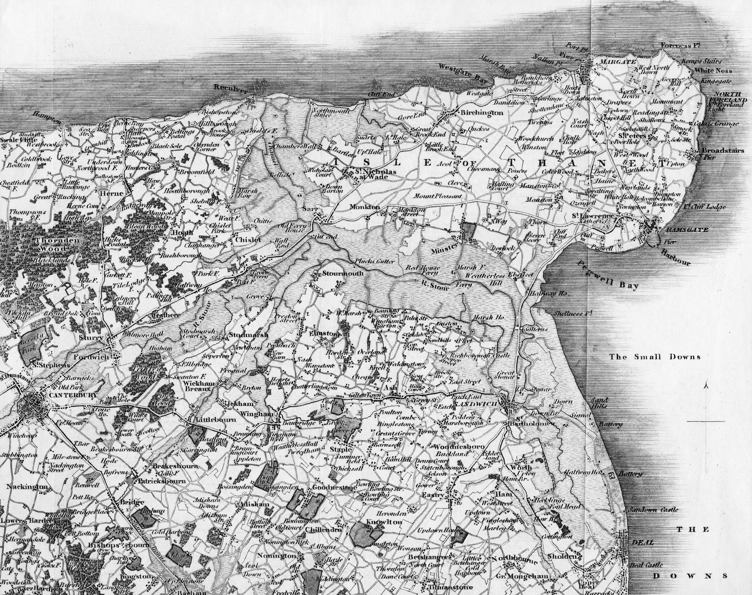
The Isle of Thanet is a manmade island click on the link for some historical background http://thanetonline.blogspot.com/2008/03/thanet-and-wantsum.html as the wind and waves come from a predominately north-westerly direction it is the costal defences north of where the Wantsum (the channel that originally separated Thanet from the mainland) was, that are most critical.

The last time the sea defences here failed was in the 1953 storm, when so much of the railway was washed away that it had to close for five months, this occurred without global warming and the resultant rise in sea levels.

If you enlarge the map above by clicking on it you will see the shaded areas that show where the Wantsum was, all of this low lying land is at considerable risk from the sea even a relatively small rise in sea levels increases that risk.

The South east Costal Group have now published their management plans for the north Wantsum sea defence and frankly they don’t look very sensible, there is also an inconsistency in them that suggests there was some disagreement among members of the group click on the link to look at them http://www.se-coastalgroup.org.uk/assets/policy-unit-4a-14-proposed.pdf as you can see the proposed managed realignment means we wind up with a much longer sea defence, it also means that the action of the sea trapped in this new inlet is likely to be considerably worse than it would be along straight coastline.

If arranging the sea defences in this peculiar way was a good idea they wouldn’t have wasted all the time and money filling in the land between the railway and the sea defences in 1953.

Tuesday, 5 August 2008

What is the most serious issue in Thanet?

The answer here is undoubtedly the decision to not hold the line of the north Wantsum sea defences, the problem here being that people forget what happens when we have a serious tidal surge storm.

In the map above, click here to enlarge, the grey area shows the Wantsum channel and the area that the sea would eventually reclaim without these defences.

Having recently published a book on our local railways I am more inclined to be interested in the other local railway books, so I was interested to read today that during the 1953 storm the railway and the land around it was simply washed away, thousands of tons of chalk had to be brought in to fill the land and the sea defences were rebuilt to a higher standard, the railway was closed for five months.

Now the environment agency the same people who don’t seem to be protecting our environment to 1995 standards have recommended letting these sea defences be left unmaintained until the sea washes them away.

The picture shows the work of replacing the land between Reculver and Bichington click here to enlarge it

Sunday, 23 March 2008

Thanet and the Wantsum

With all the recent talk of allowing the sea defences to fail that stop Thanet from becoming an island again, I thought some historical background would be helpful to some of you.

When the last ice age ended about 10,000 B.C. the glacial melt down caused by the global warming resulted in sea levels to rising by about 100 meters, separating the UK from Europe. By about 3,000 B.C. the level had filled in the ancient waterway known as the Wantsum.

The geological information suggests that in Roman times the Wantsum a considerable waterway about two miles wide and 30 feet deep. Until it silted up it was the main sea route between the Thames and the North Sea, and the English Channel. Going round the North Foreland has always represented a nautical challenge. It is our local mini Cape of Good Hope or going round the Horn.

If you consider the seas rising leaving Thanet an island, because it is higher and the surrounding land is lower, what you have to start with can be thought of as the typical children’s concept of an island, a chalk hill with a flattish top poking out of the water.

The north, east and south coasts being subject to the full force of wave action were eroded away, the result being our chalk cliffs. The west and southwest coast of Thanet faced the UK mainland and were subject to the gentle silting up of the Wantsum channel. This silting up was a very slow process and without large scale land reclamation Thanet would probably still be an island today.

From about 1,000 AD the two great monasteries of Minster and Canterbury owned most of the land around the Wanstsum and from about this time the monks started building dykes and reclaiming land.